
Trail begins and ends in Vila de Rei, district of Castelo Branco, in the province of Beira Baixa, Centro region and Médio Tejo sub-region
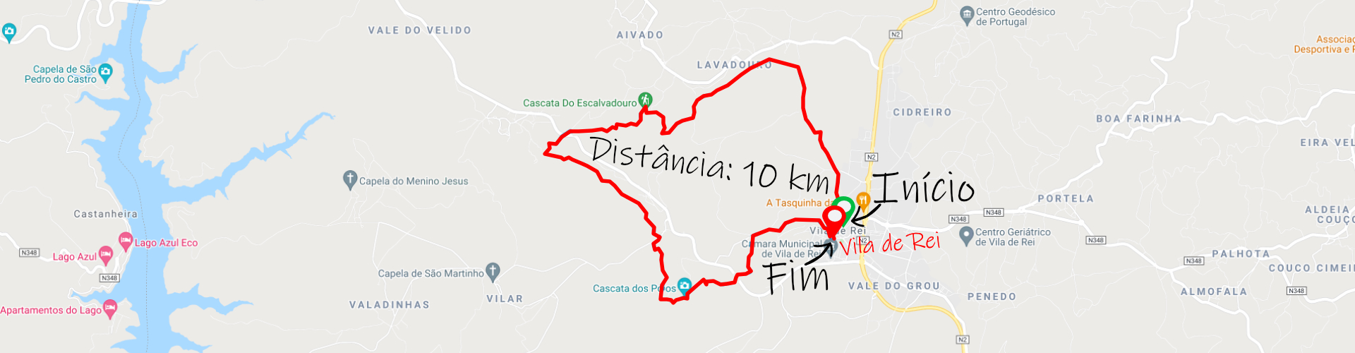
Cascatas Trail – Vila de Rei;
Distance: 10 km;
Circular: yes;
Technical Difficulty: Moderate;
Departure/Arrival Location: Vila de Rei (next to the Municipal Market).
Distance: 10 km;
Circular: yes;
Technical Difficulty: Moderate;
Departure/Arrival Location: Vila de Rei (next to the Municipal Market).
The municipality of Vila de Rei is limited to the north by the large municipality of Sertã, to the east by Mação, to the south by Sardoal and Abrantes and to the west by Ferreira do Zêzere.
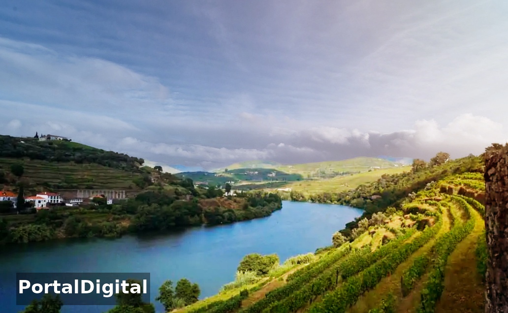
The municipality is crossed by the N2 National Road, which is the longest road in Portugal, waters from the river Zêzere da Albufeira de Castelo de Bode for water collection and bathing activities.
The trail runs along the Lavadouro river, the Vale Feito river and the town includes several waterfalls in its rocky valleys with magnificent corners and landscapes.
The fact that it presents different characteristics gives a very peaceful and relaxing atmosphere to this route, surrounded by a wild landscape in which it is possible to associate the charm of the waterfalls with the existence of numerous birds and specific flora.
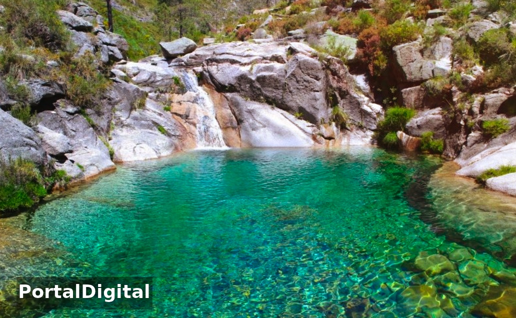
The Trail has three streams running through majestic cliffs forming idyllic wells and lagoons and small waterfalls with two imposing waterfalls surrounded by lush vegetation.
When visiting the Vila de Rei Trail with its leafy forests and hills embroidered with heather, it is one of the most surprising walking trails in Portugal.
The highlights of this Middle Tagus pedestrian route are the Escalvadouro Waterfall and the Poios Waterfall.
Make the most of your time in Vila de Rei and also go along the Penedo Furado Walkways that connect the award-winning Penedo Furado River Beach to the wonderful Penedo Furado Waterfall.
Vila de Rei is located exactly in the center of Portugal, as indicated by a geodesic landmark visible from the village where pine and eucalyptus trees predominate.
On a cool day it is ideal for walking on a walking trail: the Cascatas Trail (circular, 10 km, 4 hours).
On the walk, what you most find in the middle of a dry landscape are two waterfalls surrounded by greenery: ferns, pitchers and streams running in the middle of large cliffs.
The municipality is crossed by the N2 National Road, which is the longest road in Portugal, waters from the river Zêzere da Albufeira de Castelo de Bode for water collection and bathing activities.
The trail runs along the Lavadouro river, the Vale Feito river and the town includes several waterfalls in its rocky valleys with magnificent corners and landscapes.
The fact that it presents different characteristics gives a very peaceful and relaxing atmosphere to this route, surrounded by a wild landscape in which it is possible to associate the charm of the waterfalls with the existence of numerous birds and specific flora.
The Trail has three streams running through majestic cliffs forming idyllic wells and lagoons and small waterfalls with two imposing waterfalls surrounded by lush vegetation.
When visiting the Vila de Rei Trail with its leafy forests and hills embroidered with heather, it is one of the most surprising walking trails in Portugal.
The highlights of this Middle Tagus pedestrian route are the Escalvadouro Waterfall and the Poios Waterfall.
Make the most of your time in Vila de Rei and also go along the Penedo Furado Walkways that connect the award-winning Penedo Furado River Beach to the wonderful Penedo Furado Waterfall.
Vila de Rei is located exactly in the center of Portugal, as indicated by a geodesic landmark visible from the village where pine and eucalyptus trees predominate.
On a cool day it is ideal for walking on a walking trail: the Cascatas Trail (circular, 10 km, 4 hours).
On the walk, what you most find in the middle of a dry landscape are two waterfalls surrounded by greenery: ferns, pitchers and streams running in the middle of large cliffs.
Cascatas Trail PR1 - Escalvadouro
The hiker reaches the first Escalvadouro waterfall from the top, crossing the stream that feeds it next to a ruined watermill.
The walker descends to its base and the trail follows Ribeira das Trutas through the rocks below, passing through puddles with frogs, small waterfalls and green areas.
The walker descends to its base and the trail follows Ribeira das Trutas through the rocks below, passing through puddles with frogs, small waterfalls and green areas.
Cascatas Trail PR1- Poios
The second Poios waterfall is hidden behind thick bushes and before we see it our eyes point to the ground where we have to balance on a wooden board and only then do we see the water falling eternally.
Visitors can go further and see the butterflies, the flowers, the frogs on the rocks in the riverbanks, the smell of the eucalyptus trees and hear the sound of the water.
In the surrounding area, visitors can see the Geodesic Center of Continental Portugal in Serra da Melriça, Penedo Furado Waterfall, Água Formosa Schist Village, Fernandaires Village and River Beach, Castelo de Bode Dam and Zaboeira River Beach.
The Geodesic Center of mainland Portugal is located in Vila de Rei, marked by a geodesic landmark on the summit of Serra da Melriça and is named Picoto da Melriça.
A visit to this place is important not only for the symbolism of the place but also for the 360º view, allowing you to see Serra da Estrela on a clear day, approximately 100 km away.
The Village of Água Formosa is a small village hidden in a valley that maintains the original features clearly visible on the walls of the houses and currently has half a dozen permanent inhabitants, they also cultivate vegetable gardens next to the river that surrounds the village, flowers along the streets that can only be walked on foot and that beautify this place.