Paiva Walkways are located on the left bank of the Paiva River, in the Arouca Geopark of almost 9 km, Arouca
Paiva Walkways;
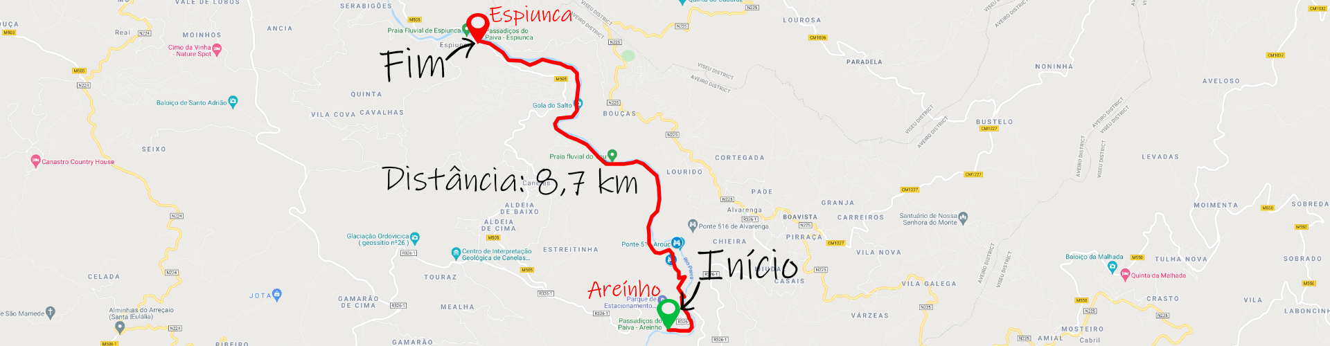
Distance: 8.7 km (17.4 km round trip);
Circular: no;
Technical Difficulty: High;
Departure Location: Areínho;
Arrival Location: Espiunca.
Distance: 8.7 km (17.4 km round trip);
Circular: no;
Technical Difficulty: High;
Departure Location: Areínho;
Arrival Location: Espiunca.
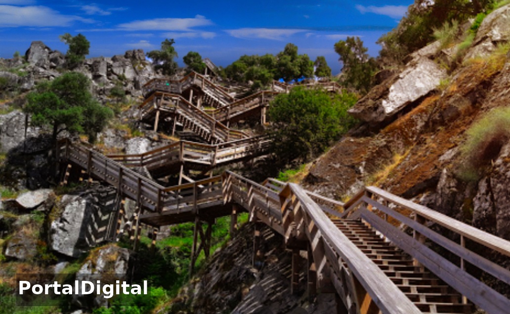
The Paiva Walkways quickly became one of the most emblematic trails and walking routes in Portugal. The Paiva River has a very clean flow with pure water and is considered by many nature lovers to be the most beautiful river in Portugal. The Arouca Chamber built a wooden route of around 8 km, almost entirely made of suspended structures in the valley.
The Passadiços do Paiva route connects Espiunca to Areinho in Canelas (next to Alvarenga) always following the rocky and steep slopes along the left bank of the Paiva river.
The Paiva Walkways Route is now part of the Arouca Geopark and can be done in both directions, which makes a total of 16 km as it is a linear route.
Visitors must follow the Passadiços do Paiva route in the Areinho-Espinuca direction and the initial climb is difficult because it is around 400 meters and then in a descending direction, which allows you to better enjoy the landscape.
The Passadiços do Paiva Route has some shade and a rest area near the Vau river beach, which is a place with a beach, puddles of water and shade.
The start of the route in Areinho and the initial climb is a bit expensive as the walkway winds through the quartzite ridges where the river carves out a valley in a deep gorge.
The Paiva Gorge is one of the geosites classified as having phenomenal beauty and you should stop frequently to regulate your breathing and also contemplate the landscape.
When you reach the viewpoints at Passadiços do Paiva you have to go down and the descent is done on a wooden walkway.
When arriving at Praia do Vau there is a wire bridge that connects the two banks of the river in this area and from the top of the bridge it is possible to take beautiful photographs of the Passadiços do Paiva.
When returning to the Passadiços do Paiva Route, at a certain point you pass through an area where the river meanders around a rock outcrop and you can admire the river with the wooden walkway accompanying this route.
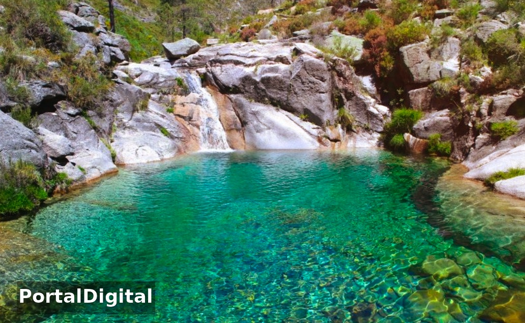
A little further on, some details of river geomorphology give the landscape extraordinary characteristics, a series of quartz benches and veins give rise to a succession of natural pools in orange and pink rocks and water lovers won't resist taking a dip.
The route of Passadiços do Paiva continues towards Espiunca where there is a river beach and ends next to the bridge over Paiva and when the river flow is reduced it is possible to cross under the bridge to reach the river beach.
Vau beach has a beautiful sandy beach with plenty of space and shade and is a great place to have a picnic and go for a swim.
Over the bridge and looking in the opposite direction to the village of Espiunca there is another geosite classified as being of particular interest in the Geopark and it is a normal tectonic fault with a three-meter tailings that testifies to the Variscan organic cycle in the Iberian Peninsula.
The walkways are located in an authentic natural sanctuary next to whitewater falls and along the trail we are treated to fantastic landscapes of unique beauty, quartz crystals and endangered species in Europe.
The most emblematic places on the walkways are Garganta do Paiva, Praia Fluvial do Vau, Gola do Salto, Cascata das Aguieiras and Falha de Espiunca.
The Passadiços do Paiva route is linear and has its start/end at Areinho river beach or Espiunca beach and start the walk at Areinho and finish at Espiunca as it is less physically demanding at the beginning of the route when you are still fresh and face the climb up the stairs.
At the start/end points there are taxis available to take you back to your means of transport and those who have energy can also choose to walk there and back.
The Passadiços do Paiva route connects Espiunca to Areinho in Canelas (next to Alvarenga) always following the rocky and steep slopes along the left bank of the Paiva river.
The Paiva Walkways Route is now part of the Arouca Geopark and can be done in both directions, which makes a total of 16 km as it is a linear route.
Visitors must follow the Passadiços do Paiva route in the Areinho-Espinuca direction and the initial climb is difficult because it is around 400 meters and then in a descending direction, which allows you to better enjoy the landscape.
The Passadiços do Paiva Route has some shade and a rest area near the Vau river beach, which is a place with a beach, puddles of water and shade.
The start of the route in Areinho and the initial climb is a bit expensive as the walkway winds through the quartzite ridges where the river carves out a valley in a deep gorge.
The Paiva Gorge is one of the geosites classified as having phenomenal beauty and you should stop frequently to regulate your breathing and also contemplate the landscape.
When you reach the viewpoints at Passadiços do Paiva you have to go down and the descent is done on a wooden walkway.
When arriving at Praia do Vau there is a wire bridge that connects the two banks of the river in this area and from the top of the bridge it is possible to take beautiful photographs of the Passadiços do Paiva.
When returning to the Passadiços do Paiva Route, at a certain point you pass through an area where the river meanders around a rock outcrop and you can admire the river with the wooden walkway accompanying this route.
A little further on, some details of river geomorphology give the landscape extraordinary characteristics, a series of quartz benches and veins give rise to a succession of natural pools in orange and pink rocks and water lovers won't resist taking a dip.
The route of Passadiços do Paiva continues towards Espiunca where there is a river beach and ends next to the bridge over Paiva and when the river flow is reduced it is possible to cross under the bridge to reach the river beach.
Vau beach has a beautiful sandy beach with plenty of space and shade and is a great place to have a picnic and go for a swim.
Over the bridge and looking in the opposite direction to the village of Espiunca there is another geosite classified as being of particular interest in the Geopark and it is a normal tectonic fault with a three-meter tailings that testifies to the Variscan organic cycle in the Iberian Peninsula.
The walkways are located in an authentic natural sanctuary next to whitewater falls and along the trail we are treated to fantastic landscapes of unique beauty, quartz crystals and endangered species in Europe.
The most emblematic places on the walkways are Garganta do Paiva, Praia Fluvial do Vau, Gola do Salto, Cascata das Aguieiras and Falha de Espiunca.
The Passadiços do Paiva route is linear and has its start/end at Areinho river beach or Espiunca beach and start the walk at Areinho and finish at Espiunca as it is less physically demanding at the beginning of the route when you are still fresh and face the climb up the stairs.
At the start/end points there are taxis available to take you back to your means of transport and those who have energy can also choose to walk there and back.