Vale do Guadiana Natural Park is a protected area, with an area of 69,700 hectares, located in the southeast of Portuguese territory, in the Baixo Alentejo region.
The Santa Maria Natural Park includes 13 protected areas: Natural Reserves of Ilhéus das Formigas and Natural Reserve of Ilhéu da Vila, Natural Monument of Pedreira do Campo, Figueiral and Prainha.
The Ilhéus das Formigas Natural Reserve is located approximately 33 nautical miles from the southeastern tip of São Miguel, approximately 20 nautical miles from the northeastern tip of Santa Maria, and constitutes a natural resource of notable relevance and a true nursery for many marine species with a total area of 52,393 hectares.
The Ilhéus das Formigas are formed by basalt flows interrupted by limestone veins that contain fossils of marine invertebrates dating back to the Miocene.
In this place you can find sponges or coral banks, and several species such as dogfish (Bodianus scrofa), grouper (Epinephelus marginatus) and kingfish (Coris julis).
Species can also be seen that pass through the islets on their migrations: the loggerhead turtle (Caretta caretta), the hammerhead shark (Sphyrna zygaena) and the whale shark (Rhincodon typus).
The Formigas lighthouse is located on the southernmost islet, being one of the "ex libris" of Azorean lighthouses, marking the reef's oceanic landscape with its characteristic profile.
The Formigas islets where the Dollabarat reef is located constitute an area of great international relevance for marine conservation which, in addition to being classified as a Site of Community Interest under the Habitats Directive, is also included in the list of Marine Protected Areas of the OSPAR Convention (OSlo-PARis Convention for the Protection of the Marine Environment of the Northeast Atlantic).
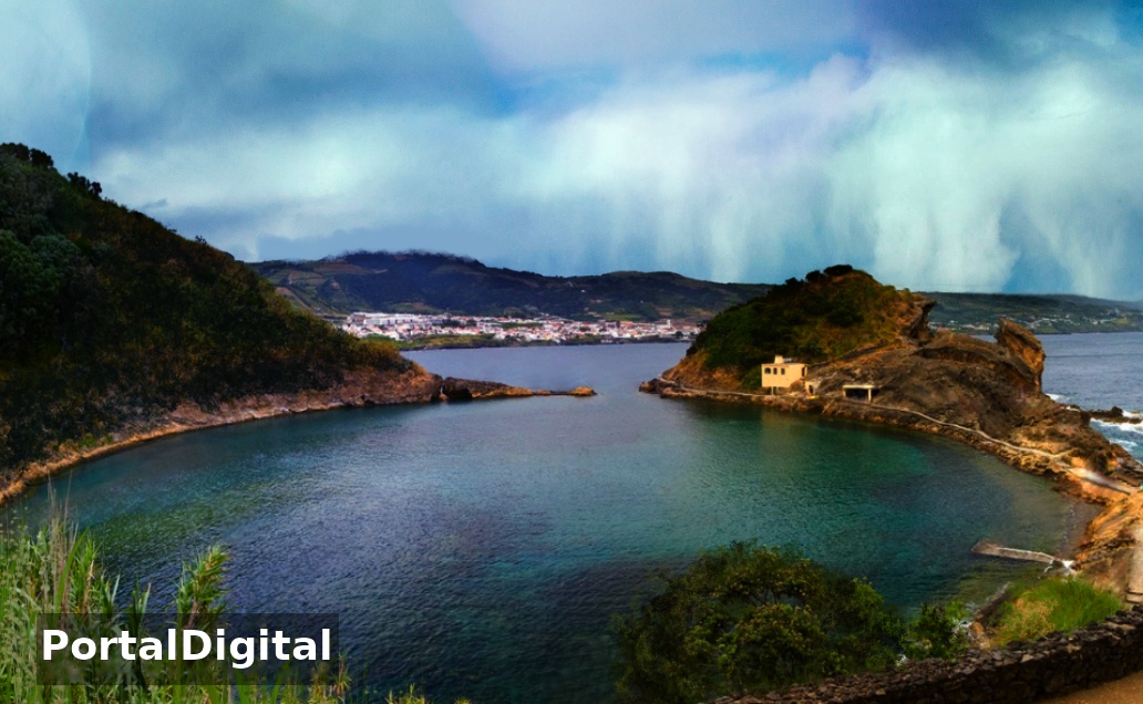
The Ilhéu de Vila Franca is located on the island of São Miguel, municipality of Vila Franca do Campo, on the south coast of the island of São Miguel, in the Azores.
The area consists of a small volcanic islet approximately 500 meters from the coast of Vila Franca, and 1200 meters from the Tagarete pier in the center of the town.
Currently, Ilhéu da Vila is only visited by researchers and people linked to nature conservation, with prior authorization.
"Pedreira do Campo" is located west of Pico do Facho in an area measuring approximately 200 meters long by 20 meters wide.
In this area, stratified deposits of sedimentary rocks with fossils (bioclasts), underwater volcanic rocks (pyroclasts) unique in the archipelago can be observed: pillows of lava and fossils are testimonies of the volcanic activities that in geological eras gave rise to the island around 5 million years before the present.
The study of the area marked by cracks and tunnels (furnas), an example of which is the so-called "Gruta do Figueiral", is a valuable contribution to the stratigraphy and paleogeography of Macaronesia, allowing a broader understanding of the geological history of the Northeast Atlantic region and the colonization of the Macaronesian islands by different species.
Prainha Bay has a semicircular shape and light-colored sand resulting from the erosion of the carbonate rocks involved.
This area is covered by the Costa Sul pedestrian trail and the Grande Rota de Santa Maria and includes geosites of the Azores Geopark, which is the UNESCO World Geopark and has several areas classified as class 2 fossil deposits of the Santa Maria Paleopark.
The Barreiro da Faneca and Costa Norte Protected Landscape area is located in the parish of São Pedro, municipality of Vila do Porto, on the island of Santa Maria, in the Azores.
The place constitutes a protected landscape of regional interest administered by the Autonomous Region of the Azores, extending from Ponta dos Frades to Ponta Norte of the island and covering Barreiro da Faneca and the Bays of Raposo, Cré and Tagarete with a surface area of 1542 hectares.
Barreiro da Faneca is an extensive surface of arid and clayey land belonging mainly to the geological unit called "Feteiras Formation" constituting a semi-desert landscape of reddish-yellow color, unique in the Azores.
In areas devoid of vegetation, soil erosion is noticeable and "dunes" caused by wind and water erosion can be observed.
In Barreiro da Faneca, around 70% of its area is covered by plant species: endemics such as heather ("Erica azorica"), whitewood ("Picconia azorica"), malfurada, "Scabiosa nitens", milkweed, laurel and beech.
Cré Bay is home to some sedimentary formations: limestone, fossiliferous conglomerates and some of these with well-preserved fossil specimens.
Raposo Bay is also of great scenic value due to its cliffs, waterfalls and river mouth.
Tagarete Bay and the adjacent area are important in geological terms due to their deposits of marine fossils.
The set of bays bordered by extremely steep and steep cliffs with heights between 50 and 150 meters above sea level are important habitat and nesting sites for several protected species of seabirds: the shearwater ("Calonectris diomedea borealis"), the common tern ("Sterna hirundo") and the rosy tern ("Sterna dougallii").
Maia Bay is located in the southwestern part of the island and is a traditional summer area characterized by a landscape marked by the presence of vineyards that climb the hillside protected by "barracks" built with basalt stone, and dominated at the top of a cliff at one of its ends by the Gonçalo Velho lighthouse.
The protected area is delimited by the coastline and the imaginary straight lines between Ponta do Castelete, downtown Maia and Ponta do Castelo.
The Recreio das Fontinhas Forest Reserve is located in the parish of Santo Espírito, municipality of Vila do Porto, on the island of Santa Maria, in the Azores.
The Fontinhas Forest Reserve has an area of 3 hectares at approximately 250 meters above sea level, is occupied by specimens of cryptomeria, sequoias and endemics such as pau-branco, heather, tree ferns ("Cyatheaceae") with some large specimens.
The Recreio Mata do Alto Forest Reserve is located in Alto Nascente, in the parish of São Pedro, municipality of Vila do Porto, on the island of Santa Maria, in the Azores, and is currently not open to the public.
The Recreio de Valverde Forest Reserve is located in the parish of Vila do Porto, municipality of Vila do Porto, on the island of Santa Maria, in the Azores.
The Valverde area, located at an altitude of around 30 meters above sea level, has an area of 4 hectares and is occupied by cupressus and eucalyptus trees and endemic species (pau-branco and heather).
The Santa Maria Natural Park is one of the nine Island Natural Parks that form part of the Azores Protected Areas Network, the territorial device for protecting nature and biodiversity in the Azores archipelago.
The Ilhéus das Formigas Natural Reserve is located approximately 33 nautical miles from the southeastern tip of São Miguel, approximately 20 nautical miles from the northeastern tip of Santa Maria, and constitutes a natural resource of notable relevance and a true nursery for many marine species with a total area of 52,393 hectares.
The Ilhéus das Formigas are formed by basalt flows interrupted by limestone veins that contain fossils of marine invertebrates dating back to the Miocene.
In this place you can find sponges or coral banks, and several species such as dogfish (Bodianus scrofa), grouper (Epinephelus marginatus) and kingfish (Coris julis).
Species can also be seen that pass through the islets on their migrations: the loggerhead turtle (Caretta caretta), the hammerhead shark (Sphyrna zygaena) and the whale shark (Rhincodon typus).
The Formigas lighthouse is located on the southernmost islet, being one of the "ex libris" of Azorean lighthouses, marking the reef's oceanic landscape with its characteristic profile.
The Formigas islets where the Dollabarat reef is located constitute an area of great international relevance for marine conservation which, in addition to being classified as a Site of Community Interest under the Habitats Directive, is also included in the list of Marine Protected Areas of the OSPAR Convention (OSlo-PARis Convention for the Protection of the Marine Environment of the Northeast Atlantic).
The Ilhéu de Vila Franca is located on the island of São Miguel, municipality of Vila Franca do Campo, on the south coast of the island of São Miguel, in the Azores.
The area consists of a small volcanic islet approximately 500 meters from the coast of Vila Franca, and 1200 meters from the Tagarete pier in the center of the town.
Currently, Ilhéu da Vila is only visited by researchers and people linked to nature conservation, with prior authorization.
"Pedreira do Campo" is located west of Pico do Facho in an area measuring approximately 200 meters long by 20 meters wide.
In this area, stratified deposits of sedimentary rocks with fossils (bioclasts), underwater volcanic rocks (pyroclasts) unique in the archipelago can be observed: pillows of lava and fossils are testimonies of the volcanic activities that in geological eras gave rise to the island around 5 million years before the present.
The study of the area marked by cracks and tunnels (furnas), an example of which is the so-called "Gruta do Figueiral", is a valuable contribution to the stratigraphy and paleogeography of Macaronesia, allowing a broader understanding of the geological history of the Northeast Atlantic region and the colonization of the Macaronesian islands by different species.
Prainha Bay has a semicircular shape and light-colored sand resulting from the erosion of the carbonate rocks involved.
This area is covered by the Costa Sul pedestrian trail and the Grande Rota de Santa Maria and includes geosites of the Azores Geopark, which is the UNESCO World Geopark and has several areas classified as class 2 fossil deposits of the Santa Maria Paleopark.
The Barreiro da Faneca and Costa Norte Protected Landscape area is located in the parish of São Pedro, municipality of Vila do Porto, on the island of Santa Maria, in the Azores.
The place constitutes a protected landscape of regional interest administered by the Autonomous Region of the Azores, extending from Ponta dos Frades to Ponta Norte of the island and covering Barreiro da Faneca and the Bays of Raposo, Cré and Tagarete with a surface area of 1542 hectares.
Barreiro da Faneca is an extensive surface of arid and clayey land belonging mainly to the geological unit called "Feteiras Formation" constituting a semi-desert landscape of reddish-yellow color, unique in the Azores.
In areas devoid of vegetation, soil erosion is noticeable and "dunes" caused by wind and water erosion can be observed.
In Barreiro da Faneca, around 70% of its area is covered by plant species: endemics such as heather ("Erica azorica"), whitewood ("Picconia azorica"), malfurada, "Scabiosa nitens", milkweed, laurel and beech.
Cré Bay is home to some sedimentary formations: limestone, fossiliferous conglomerates and some of these with well-preserved fossil specimens.
Raposo Bay is also of great scenic value due to its cliffs, waterfalls and river mouth.
Tagarete Bay and the adjacent area are important in geological terms due to their deposits of marine fossils.
The set of bays bordered by extremely steep and steep cliffs with heights between 50 and 150 meters above sea level are important habitat and nesting sites for several protected species of seabirds: the shearwater ("Calonectris diomedea borealis"), the common tern ("Sterna hirundo") and the rosy tern ("Sterna dougallii").
Maia Bay is located in the southwestern part of the island and is a traditional summer area characterized by a landscape marked by the presence of vineyards that climb the hillside protected by "barracks" built with basalt stone, and dominated at the top of a cliff at one of its ends by the Gonçalo Velho lighthouse.
The protected area is delimited by the coastline and the imaginary straight lines between Ponta do Castelete, downtown Maia and Ponta do Castelo.
The Recreio das Fontinhas Forest Reserve is located in the parish of Santo Espírito, municipality of Vila do Porto, on the island of Santa Maria, in the Azores.
The Fontinhas Forest Reserve has an area of 3 hectares at approximately 250 meters above sea level, is occupied by specimens of cryptomeria, sequoias and endemics such as pau-branco, heather, tree ferns ("Cyatheaceae") with some large specimens.
The Recreio Mata do Alto Forest Reserve is located in Alto Nascente, in the parish of São Pedro, municipality of Vila do Porto, on the island of Santa Maria, in the Azores, and is currently not open to the public.
The Recreio de Valverde Forest Reserve is located in the parish of Vila do Porto, municipality of Vila do Porto, on the island of Santa Maria, in the Azores.
The Valverde area, located at an altitude of around 30 meters above sea level, has an area of 4 hectares and is occupied by cupressus and eucalyptus trees and endemic species (pau-branco and heather).
The Santa Maria Natural Park is one of the nine Island Natural Parks that form part of the Azores Protected Areas Network, the territorial device for protecting nature and biodiversity in the Azores archipelago.