
The Orvalho Walkways located in the Naturtejo Geopark area are located more specifically in Orvalho, in the municipality of Oleiros and in the district of Castelo Branco
GeoRota do Orvalho - Oleiros;
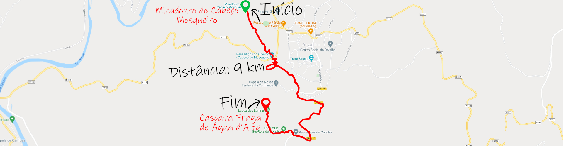
Distance: 9 km;
Circular: no;
Technical Difficulty: Moderate;
Departure Location: Cabeço Mosqueiro Viewpoint;
Arrival location: Cascata Fraga de Água d’Alta.
Distance: 9 km;
Circular: no;
Technical Difficulty: Moderate;
Departure Location: Cabeço Mosqueiro Viewpoint;
Arrival location: Cascata Fraga de Água d’Alta.
In the heart of Beira Baixa, in the middle of Naturtejo Geopark, there is one of the best trails and walking routes in Portugal called GeoRota do Orvalho, which came to the fore due to the construction of the fantastic Walkways of Orvalho.
The Passadiços do Orvalho and the Fraga da Água d’Alta Waterfall are recent attractions in the Beira Baixa region and promise to be one of the next sensations in Portugal.
The Passadiços do Orvalho trail (PR3 OLR) is 8.9 km long and is a non-circular circuit, but there is a way to start and end in the same place, covering more than 1.5 km and making it a circular route.
The 8.9km is not always done on footbridges but a large part of the trail is done on dirt.
The starting point for the walk is at the Orvalho Parish Council in the center of the village and you will soon see tourist information regarding the Walkways of Orvalho and a few meters later the first point of interest is the Igreja Matriz de Orvalho.
The first part of the route is 1/4 of the walk on the outskirts of the village of Orvalho, moving on to the second phase where you first see the Fraga da Água d’Alta Waterfall and Lagoa das Lontras.
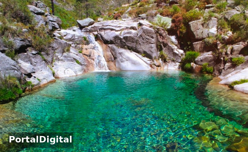
Fraga da Água d''Alta Waterfall
The Fraga da Água d’Alta Waterfall is in the middle of the route and is perfect because there are several tables and spaces to have a picnic alone or with your group and adventurers can cool off next to the waterfall.
Lotters Lagoon
The route between Fraga da Água d’Alta Waterfall and Lagoa das Lontras is the most beautiful part of the trail and part of the walk is done in the company of the watercourse that feeds the waterfall and subsequently the lagoon.
A very pleasant area to walk around is also an area with plenty of vegetation, which offers shade and leads to greater interaction with mother nature.
In this place, it is also here that wooden walkways and bridges gain a prominent role because they blend perfectly with the surrounding landscape.
In this case, the bridges built to cross the watercourse make the place even more beautiful and pleasant.
When the visitor arrives at Lagoa das Lontras where there is a mill in ruins, it is time to turn right, make a demanding climb and head towards Cabeço do Mosqueiro.
Cabeço do Mosqueiro Viewpoint
The visitor, after making the climb, will return to the intersection with the two signs indicating the waterfall and the lagoon.
From here you can begin to see the Cabeço do Mosqueiro Viewpoint which dictates the end of the “official” route. It is in this circular option that the arrival point is in the center of the village of Orvalho where you started.
After 6km of walking looking at Cabeço do Mosqueiro and the number of stairs you will have to climb, believe that in the end it will be well worth it.
The route also passes through two other points of interest, which are the Calçada Romana and Forno das Mouras.
The first stop before reaching the top of Cabeço do Mosqueiro is the viewpoint with a wonderful panoramic landscape and a sign about Aldeia de Orvalho.
The top of the Cabeço do Mosqueiro Viewpoint offers an incredible 360-degree view and has a picnic area with lots of shade, picnic tables and barbecues and the trail ends here.
The visitor travels more than 1.5km and returns to the center of Orvalho, descending Cabeço do Mosqueiro and following the N112 and in 20 minutes reaches the final destination.
Orvalho Walkways
Visitors who want to see the main route that comes from the N112 or N238, the best option would be to start at Cabeço do Mosqueiro, otherwise you should start at the Fraga da Água d’Alta Waterfall which is further south and on a secondary road.
The large hill on the left is Cabeço do Mosqueiro and to get there from the N238 you will find a sign saying “Parque de Merendas Miradouro” just go up a narrow road and go down one of the stairs to reach the Cascata da Fraga da Água d’Alta.
To get to Lagoa das Lontras, visitors have to walk a little but it's worth it because this part of the trail is really beautiful.
After Lagoa das Lontras, the best solution is to return the way you came and the tour ends.
The walk along Passadiços do Orvalho is best done in spring and autumn because in summer the temperatures are very high and in winter with rain the ground can become dangerous.
On the GeoRota do Orvalho trail, you will travel the entire Passadiços do Orvalho and discover a series of geomonuments classified by UNESCO, such as the Fraga de Água d´Alta Waterfall and Cabeço do Mosqueiro and some of the most iconic landscapes of Beira Baixa.
On the route along the Passadiços do Orvalho you can admire the Frágua de Água d´Alta Waterfall, considered one of the most beautiful in Beiras, and the Miradouro do Mosqueiro with stunning views over the Center of Portugal.
The GeoRota do Orvalho trail starts at Cabeço do Mosqueiro and ends at the Fraga de Água d’Alta Waterfall and on a hot day you can take a dip in the refreshing waters.