It is located between Serra da Freita and Serra de S. Macário is one of the uninhabited and most mythical places in Portugal
Drave Trail, the Magic Village – PR 14 Arouca;
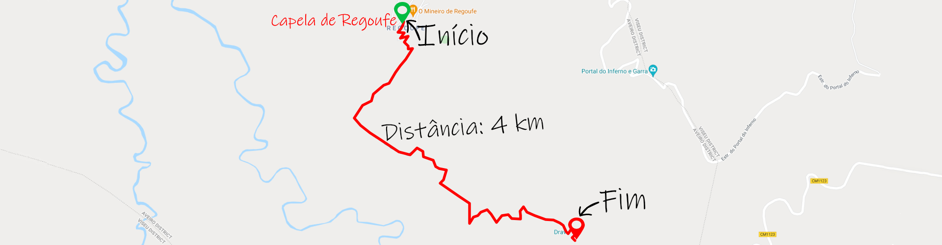
Distance: 4 km (8 km round trip);
Circular: no;
Technical Difficulty: Moderate;
Departure/Arrival Location: Regoufe Chapel.
Distance: 4 km (8 km round trip);
Circular: no;
Technical Difficulty: Moderate;
Departure/Arrival Location: Regoufe Chapel.
In Serra da Freita you can visit the famous "abandoned" village of Drave, located 4km walk from the village of Regoufe.
Drave is indeed a magical place, a mythical village, uninhabited and apparently lost in the Mountain that can only be reached on foot, offering us dream scenarios that will remain in our memories for a long time.
The schist village is magical and the nature that surrounds it is not far behind and is another one that has to be on the list of the best trails and walking routes in Portugal and can be accessed on foot.
The trail is linear, starting/ending at the Regoufe Chapel. The route begins in the village that is nestled right in the center of Serra de Freita, via a mountain road that can be taken from São Pedro do Sul and for those coming from the coast from Arouca where the mountains wind with tight curves and stunning views.
Starting from the village of Regoufe is a point of interest where you can enjoy the rhythm of rural life and one of the highlights is walking through the village from the top where you can park your car next to the chapel and going to the bottom of the village next to a bridge that crosses the Ribeira de Regoufe, passing through the stone houses, greeting the inhabitants and watching chickens and turkeys roaming around the village.
The village of Regoufe, remote from Serra da Arada, which during the two great wars of the last century had singular importance.
In its subsoil and surrounding mountains, tons of tungsten were extracted and exported to manufacture war material for the Allied forces and the ruins/stories of that time are there to be discovered.
A little above the village, visitors can explore a Geosite of the Park and what remains of the Poça de Cadela Mining Complex (Minas de Regoufe) from where tons of tungsten were extracted and later exported during World War II.
The Drave Village Trail starts after the Regoufe bridge and overall has a low level of difficulty but is largely exposed to the sun so it is best to wear head protection, sunscreen and plenty of water.
Visitors travel the trail in around 2 hours to cover the 4 kilometers that are not flat to the village and approximately the same altitude as Regoufe.
When crossing the bridge, the visitor begins a very steep climb over rocky terrain and when they reach the top they have a privileged view of Regoufe and the mountains with shale hills (today without trees due to successive fires in the mountains) topped by granite ridges where today the wind turbines stand.
The path is along a road and rock and is always going down to Drave and further on we enter a path with some trees and shade and we have the first glimpse of Drave.
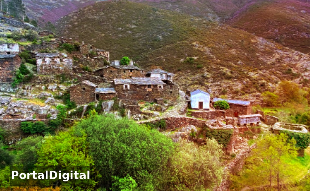
Arrival at the village of Drave when we see for the first time the houses made entirely of schist and hear the sound of the crystal clear waters of the Palhais river.
Drave lives up to the name magic because there is something transcendent about that small group of houses lost in the middle of the mountains, nestled at the bottom of the valley crossed by Ribeira de Palhais.
When the visitor arrives at the village of Drave, he sees some houses, most of them in ruins and few being restored, passing by the Church, the Solar dos Martins and the remains of a cellar in the basement of one of Drave's houses.
Drave was inhabited until the beginning of this century but it was only in 1993 that the telephone arrived there, as can be seen on a plaque posted there in the church.
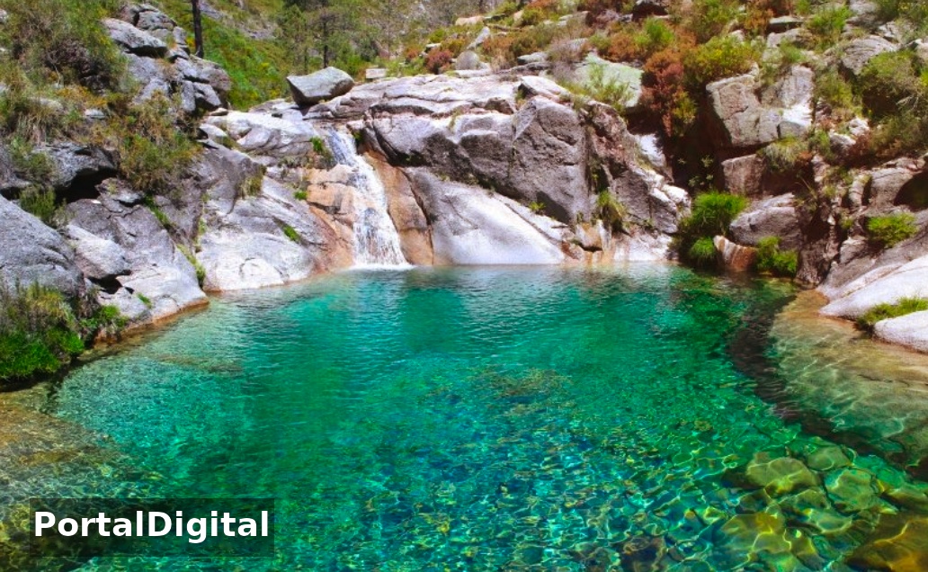
Currently the village does not have any permanent inhabitants and its location and mystique mean that those who visit it are enchanted by it and cool off in the natural pools of the Drave River.
The return trail from Drave to Regoufe follows the same route in the back and the climb is gentler at the beginning and in the middle of the route it becomes more steep and exposed to the sun.
On the final descent you need to be careful, you have to descend slowly and watch where you put your feet as the terrain is prone to slips and sprains and behind was a village forgotten by time and its people.
Drave is indeed a magical place, a mythical village, uninhabited and apparently lost in the Mountain that can only be reached on foot, offering us dream scenarios that will remain in our memories for a long time.
The schist village is magical and the nature that surrounds it is not far behind and is another one that has to be on the list of the best trails and walking routes in Portugal and can be accessed on foot.
The trail is linear, starting/ending at the Regoufe Chapel. The route begins in the village that is nestled right in the center of Serra de Freita, via a mountain road that can be taken from São Pedro do Sul and for those coming from the coast from Arouca where the mountains wind with tight curves and stunning views.
Starting from the village of Regoufe is a point of interest where you can enjoy the rhythm of rural life and one of the highlights is walking through the village from the top where you can park your car next to the chapel and going to the bottom of the village next to a bridge that crosses the Ribeira de Regoufe, passing through the stone houses, greeting the inhabitants and watching chickens and turkeys roaming around the village.
The village of Regoufe, remote from Serra da Arada, which during the two great wars of the last century had singular importance.
In its subsoil and surrounding mountains, tons of tungsten were extracted and exported to manufacture war material for the Allied forces and the ruins/stories of that time are there to be discovered.
A little above the village, visitors can explore a Geosite of the Park and what remains of the Poça de Cadela Mining Complex (Minas de Regoufe) from where tons of tungsten were extracted and later exported during World War II.
The Drave Village Trail starts after the Regoufe bridge and overall has a low level of difficulty but is largely exposed to the sun so it is best to wear head protection, sunscreen and plenty of water.
Visitors travel the trail in around 2 hours to cover the 4 kilometers that are not flat to the village and approximately the same altitude as Regoufe.
When crossing the bridge, the visitor begins a very steep climb over rocky terrain and when they reach the top they have a privileged view of Regoufe and the mountains with shale hills (today without trees due to successive fires in the mountains) topped by granite ridges where today the wind turbines stand.
The path is along a road and rock and is always going down to Drave and further on we enter a path with some trees and shade and we have the first glimpse of Drave.
Arrival at the village of Drave when we see for the first time the houses made entirely of schist and hear the sound of the crystal clear waters of the Palhais river.
Drave lives up to the name magic because there is something transcendent about that small group of houses lost in the middle of the mountains, nestled at the bottom of the valley crossed by Ribeira de Palhais.
When the visitor arrives at the village of Drave, he sees some houses, most of them in ruins and few being restored, passing by the Church, the Solar dos Martins and the remains of a cellar in the basement of one of Drave's houses.
Drave was inhabited until the beginning of this century but it was only in 1993 that the telephone arrived there, as can be seen on a plaque posted there in the church.
Currently the village does not have any permanent inhabitants and its location and mystique mean that those who visit it are enchanted by it and cool off in the natural pools of the Drave River.
The return trail from Drave to Regoufe follows the same route in the back and the climb is gentler at the beginning and in the middle of the route it becomes more steep and exposed to the sun.
On the final descent you need to be careful, you have to descend slowly and watch where you put your feet as the terrain is prone to slips and sprains and behind was a village forgotten by time and its people.